
Onboard Edge AI: How Orbital Intelligence Replaces Days of Ground Analysis for National Security


“When hypersonic missiles travel hundreds of kilometers in minutes, and drone swarms reach targets before decisions can be made, real-time or near-real-time surveillance becomes not just helpful, but critical for survival,” stated Air Marshal Ashutosh Dixit, Chief of Integrated Defence Staff to Chairman Chiefs of Staffs Committee, regarding the compressed timelines of modern warfare. His emphasis on the OODA loop (observe, orient, decide, act), which has compressed from hours to minutes, reflects India’s urgent need to transform satellite data into actionable intelligence at the speed of threat evolution.
This gap between data collection and actionable intelligence creates vulnerabilities that adversaries exploit daily. Modern satellites capture terabytes of imagery, but traditional workflows require downloading, processing, and analyzing data at ground stations. This cycle transforms real-time threats into historical records.
When Minutes Matter: The Cost of Delay
India’s border security demonstrates the critical impact of processing delays. Consider the surveillance challenge along the 3,488 km India-China border, where satellite flyovers capture movement patterns at key mountain locations. By the time this imagery reaches ground stations through limited downlink windows, undergoes processing at centralized facilities, and reaches military command centers, tactical opportunities vanish.
Defense Minister Hon’ble Shri Rajnath Singh emphasized in 2025: “Space capacities in the Low Earth Orbit are transforming military intelligence, persistent surveillance, positioning, targeting and communications, thus taking combat to a new high.” Yet frontline forces rely on intelligence that arrives hours after collection.
During Operation Sindoor, satellite data provided crucial intelligence on drone and missile trajectories, but processing delays meant reactive rather than preventive responses. As noted by defense analysts, India’s Rs 27,000 crore SBS-III project aims to deploy 52 satellites with AI-driven analytics and synthetic aperture radar for real-time monitoring of troop movements and missile deployments.
Air Marshal Dixit further elaborated on the strategic imperative: “The decisive advantage in modern warfare lies in the ability to see first, see farthest, and see most accurately. When weapons can strike targets hundreds of kilometres away with pinpoint accuracy, he traditional concepts of front, rear and flanks combat zones and depth areas all become irrelevant. What we call the front and the theatre merge into one. This new reality demands that we extend our surveillance envelope far beyond what previous generations could have even imagined. We must detect, identify and track potential threats not when they approach our borders, but when they are still in their staging areas, airfields and bases, deep within adversary territory. This existed as a concept even earlier but today we have the means to realise it.”
The Technology Gap: Why Edge AI Remained Elusive
Despite urgent operational needs, multiple barriers have prevented widespread edge AI adoption in Indian and global satellite systems:
Data Bottlenecks from Growing Sensor Networks
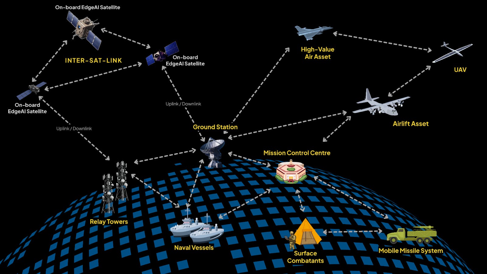
Modern satellites, drones, and ground sensors generate massive volumes of data, but traditionally this information has to be transmitted to distant data centers for processing a workflow that quickly becomes impractical. Bandwidth limitations, high transmission costs, and latency make it difficult to move such large datasets in real time, especially from remote or hostile environments. This creates a significant technology gap, where valuable insights are delayed or lost entirely, highlighting the growing need for efficient edge processing solutions.
Processing Without Accuracy Loss
The fundamental challenge lies in maintaining intelligence quality despite severe constraints. According to IEEE research, space-qualified processors operate with 10–100 watts of power compared to terrestrial data centers using megawatts. Storage limitations mean satellites can buffer only hours of raw data. Bandwidth restrictions limit downlink to 1–2 Gbps, while sensors generate 10–100 Gbps. Traditional compression destroys critical details needed for threat detection. Edge AI must achieve 95%+ accuracy while operating within these constraints, a challenge that has stymied deployment for decades.
The GEOAI Revolution: Processing at the Point of Collection
Recent breakthroughs demonstrate that GEOAI models (geospatial AI optimized for orbital deployment) can transform satellites from passive collectors into intelligent analysts. These models process imagery directly in orbit, identifying threats, filtering noise, and prioritizing critical information for immediate transmission.
ESA’s Φsat-2 mission proved the concept, running six AI applications simultaneously on a CubeSat. The system detects vessels, identifies wildfires, and generates emergency maps, all within minutes of image capture.
The key to closing the gap lies in two complementary capabilities working in concert: rapid GEOAI model development that adapts to emerging threats, and real-time orbital processing infrastructure that executes these models instantly. Organizations need platforms that can develop and deploy new GEOAI models in weeks rather than years, while simultaneously managing satellite operations to process multiple data streams in real time. This combination creates the competitive advantage that transforms satellites from data collectors into decision enablers.
Operational Integration: Where Speed Meets Intelligence
The transformation occurs when integrated systems combine GEOAI model libraries with real-time tasking and operations management. This fusion enables immediate threat detection, adaptive intelligence gathering, and multi-source correlation that fundamentally changes security operations.
Real-World Applications
Maritime surveillance systems can now detect suspicious vessel activity within minutes. Border forces gain real-time visibility into unauthorized crossings using live satellite feeds. SkyServe enhances these operations with EdgeAI-powered insights delivered directly from orbit, enabling faster response to critical events such as oil spills, illicit shipping, or encroachments.
These edge applications reduce reliance on ground downlink and provide actionable intelligence for defense, disaster response, and infrastructure security where seconds matter.
Implementation Pathways: Becoming Edge Ready
Organizations must systematically prepare for edge AI deployment through seven critical steps:
Data Curation and Preprocessing
Collect diverse, high-quality geospatial datasets from multiple sources including satellites, drones, sensors, and ground truth validation. Indian defense agencies require comprehensive datasets covering varied terrain from desert borders to mountain passes, with annotations for threat patterns unique to regional adversaries.
Key activities:
Normalize, clean, and annotate data for AI tasks including object classification, threat detection, and terrain segmentation
Simulate edge conditions with low resolution, noise, or partial data availability to ensure model robustness
Integrate satellite surveillance with GIS mapping for precise georeferencing and multi-layer analysis critical for border monitoring operations
Model Selection and Optimization
Choose architectures optimized for space constraints while ensuring models meet strict orbital computing requirements. Quantized neural networks reduce memory footprint by 75% while maintaining accuracy.
Optimization requirements:
Optimize for inference time and memory usage in constrained computing environments
Ensure models do not exceed RAM limits or generate output beyond allowable size
Validate that inference completes within milliseconds and memory usage remains within allocated boundaries
Apply pruning to remove unnecessary connections and knowledge distillation to transfer capabilities from large models to compact versions suitable for orbital deployment
Onboard Deployment Readiness
Ensure that both software and hardware compatibility are aligned with the use case requirements and objectives. Models must operate within the power envelope of the intended use case and adhere to memory constraints (4–16 GB). Testing must validate performance across the full operational temperature range of the target platform.Reliability Engineering
Implement redundancy through ensemble models that cross-verify detections. Error correction codes protect model weights from radiation-induced bit flips. Graceful degradation ensures partial functionality even with component failures.Integration with Edge Pipelines
Develop APIs for seamless data flow from sensors through AI models to communication systems. Standardize interfaces for model updates via ground commands. Enable autonomous operation during communication blackouts.Test and Validate in Real Environments
Run integrated hardware and software tests that simulate real orbital conditions. Focus on key constraints such as limited sensor fidelity, strict memory ceilings, and tight compute budgets. Validate that inference outputs stay within size limits and complete processing within the allocated time windows.
Indian organizations should prioritize test scenarios that reflect regional risks, especially maritime threats in the Indian Ocean Region. Ensure AI models deliver accurate results under these conditions and maintain performance within the resource limits of space-qualified systems.Security Implementation
Protect deployed systems through comprehensive security measures:
Encrypt model weights and inference results
Implement authentication for model updates
Protect against adversarial attacks designed to fool AI systems
Establish audit trails for all automated decisions affecting security operations
SkyServe: Proven Edge AI Leadership
SkyServe has operationalized this vision through its EdgeAI platform, enabling rapid development, deployment, and management of AI models directly on orbit. This approach delivers real-time insights from space, eliminating delays associated with ground-based processing.
Proven Track Record
With four completed missions including partnerships with D-Orbit (Mission Matterhorn) and Loft Orbital (Mission Denali), SkyServe has demonstrated:
5x improvement in data transmission efficiency
Processing intelligence directly in orbit on existing satellite hardware
Organizations don’t need new satellites to gain edge AI capabilities
Sensor-agnostic capabilities across multispectral, hyperspectral, SAR, IoT, RF, and other payload types
Dual-Platform Advantage
The company’s approach uniquely addresses both sides of the equation:
SURGE enables development of mission-specific GEOAI models in weeks rather than months, while STORM manages the orbital infrastructure to execute these models in real time.
This combination has delivered tangible results including vegetation analysis, cloud detection, and anomaly identification over strategic regional areas, all processed within seconds of capture rather than hours after ground station download.
The Strategic Path Forward
SkyServe continues advancing its technology through collaborations with leading private and public space agencies like ISRO, NASA, and IN-SPACe, while expanding partnerships across the defense sector. SkyServe focuses on making edge AI accessible to government security agencies by:
Reducing deployment time from years to months
Ensuring compatibility with existing satellite infrastructure
Enhancing automated threat detection algorithms
Expanding multi-sensor fusion capabilities
Enabling even faster model deployment cycles to address emerging security challenges
The Imperative for Action
As Air Marshal Ashutosh Dixit emphasized: “Our adversaries are not waiting. Every day we delay implementing real-time space intelligence capabilities is a day they gain advantage.”
The evidence is clear: organizations implementing integrated edge AI platforms gain immediate competitive advantages through:
Faster response: processing at the speed of collection
Broader coverage: multiple data streams analyzed simultaneously
Adaptive capabilities: rapid deployment of new threat detection models
In an environment where seconds determine outcomes, the advantage belongs to those who process at the speed of collection, adapt at the pace of threats, and decide faster than adversaries can act.
Conclusion
The transformation from traditional ground-based satellite intelligence processing to real-time edge AI represents a fundamental shift in national security capabilities.
India’s investment in the SBS-III programme, combined with emerging technologies from companies like SkyServe, positions the nation to close the critical gap between data collection and actionable intelligence.
The compressed timelines of modern warfare, where hypersonic missiles and drone swarms operate in minutes, demand intelligence systems that match the speed of threats. Edge AI and GEOAI technologies have matured from concept to operational reality, proven through missions in orbit and real-world defense applications.
For defense agencies and satellite operators, the path forward is clear: systematic preparation through the seven implementation steps, adoption of integrated platforms that combine rapid model development with orbital operations management, and commitment to continuous advancement as threats evolve.
The competitive advantage in space-based intelligence now belongs to those who process at the point of collection, transform satellites from passive sensors into intelligent analysts, and deliver actionable intelligence measured in seconds rather than hours.
Read
Love this perspective! The urgency of real-time procesing you highlight is so critcal. Honestly, makes you think everything from national security to our delivery apps needs edge AI now. Spot on!