Proactive Protection: Monitor Your Property Lines in Real-Time with Satellite Imagery and Edge Computing
Introduction
Encroachments are value-depreciating events for any parcel of land. Sequences of encroachment can cause not just inconvenience to any property but also have financial impacts for residential as well as commercial land, utility installations like cross-country pipelines and power transmission, mining blocks as well as railway lines.
Arya, a product developer studying the above, saw it as a market opportunity and listed more thrilling details. he came across real-world scenarios that played out in the recent past and the size of this unmet need:
"Forest land five times Delhi's geographical area under encroachment, govt data shows. The latest data showed that 750,633 hectares or 7,506.33 square kilometers of forest land has been encroached in the country." - Deccan Herald (05 January 2024)
In the USA, the direct financial impact of vandalism and theft in vacant properties is significant, with average losses ranging from $2,000 to over $20,000 per incident. - The Urgent Need for Security in Vacant Commercial Properties: A Comprehensive Guide - 06 - Feb -2024
The robust growth (8.27% CAGR 2024-2028) in the security services market highlights an increasing demand for private security. This demand is intricately connected to the issue of property encroachment, as property owners seek security services to defend against boundary violations.- Statista
Objectives for Effective Solutions
Enthused by the numbers he's seen, Arya looks into the services addressing property encroachment issues.
The existing solutions vary from assigning security personnel to installing CCTV cameras and using drones. These have been the top touch-points for most property owners in tackling encroachment.
At the back of his mind, Arya understands that these techniques have limitations staring from the actual encroachment detection to reporting. For example, malpractice is possible while engaging security personnel; monitoring vacant land on a large scale with cameras is not really practical and so goes for drones as a deterrent considering the lack of regulatory clarity and the risk of injury to humans on the ground.
From the survey, Arya derived a few objectives that a typical service should deliver:
Objective - 1 : Ensure effective monitoring by detecting encroachment in a timely manner.
Objective - 2 : Communicate the essence of the incident to the stakeholder with the least delay.
Objective - 3 : Cost-effectiveness - Cover budget aspirations of property owners at different levels and different categories of properties.
Searching for scalable solutions, Arya found that "Remote monitoring" addresses the limitations of the on-site solutions he has seen so far. Remote sensing fused with geospatial technology seems to be already addressing these challenges, and the ability for better encroachment detection is surging with all the new satellites being launched to space!
When digging deeper into this, Arya finds that high-resolution satellite images are a critical input.
Arya encounters Aleks Buczkowski's blog, which discusses the market availability of satellite imagery, particularly emphasizing the "Minimum order area" and pricing based on dollars per km².
Though this solution is technically more effective, Arya found a gap in cost-effectiveness when trying to sketch out a prototype solution.

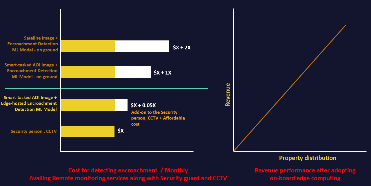
For monitoring a vacant parcel of land spanning 0.23 km², Arya tries to collect the combined solution cost for the top-rated offering today (CCTV with motion-detection and ability to have an armed security person on call) and compared that with a solution that includes an option to leverage the satellite image-based idea.

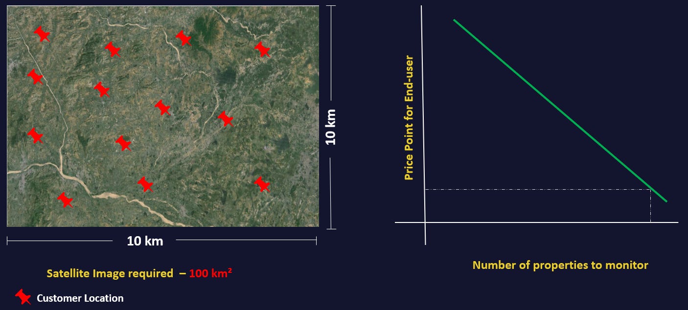
He realizes that a high resolution satellite image covering 100 km² has to be acquired from the market, to monitor his precious 0.23 km².
Also, Arya finds that the satellite images will always remain under-utilized and become a pain-point.While visualizing the business scenarios, Arya came up with two.
1. More properties to monitor in a smaller region.
Here, a satellite image was acquired for 100km² (smaller region) in conjunction with more properties to monitor, assuming even a measly three-fold of the security and CCTV customers, then using satellite image for this scenario looks competitive.

2. More properties to monitor at the State/Country level.
If Arya were to service property owners country-wide, then he would certainly get more customers, but he would need to procure a massive number of satellite images.
For example, if ten properties each spanning one km² are spread across ten different US states, then imagery to be acquired would be 1,000 km², and the utilization ratio would stand at 1% even after the sizable spend.
The existing and traditional methods seem more viable cost-wise in this scenario, but the first two objectives will still need to be addressed.
Arya understands that scaling the encroachment-monitoring service to the state/country level turns the business potential from excellent to vulnerable due to the meager utilization rate of images. If one compares with high-profitability SaaS businesses, this current iteration of the monitoring solution seems to be going in the wrong direction - the cost to maintain a larger customer base just keeps going up! His conclusion is that the utilization rate of satellite imagery procured has to be high in order to result in sustainable and profitable growth of his business.
Area-of-Interest Matters
Arya, after a week of thrashing out his ideas with friends and over caffeine shots in cafes, comes up with a seemingly obvious question:
"A satellite image is required to detect encroachment. But for 100 km² or the area of interest?"
He blurts out, loudly, "Image of the Area of Interest!".
This epiphany ignites another search, "Is it possible to get an image of just the area of interest?"
Arya calls up his old school friend, now a professor or Remote Sensing at a prestigious university, and tries his luck. Dr. Neil winces at the question with a knowing smile and explains, "I have had to defend satellite imaging so many times, especially when this specific question comes up. The field of remote-sensing has been a boon for us scientists, but it hasn't really changed to cater to commercial needs where costs need to be controlled in relation to the final offering's market potential and end-user preferences". After giving a long pause, Neil has a twinkle in his eye and says, "There is a way, and this is a new development where the satellite, when provided with the area of your interest, can figure out which parts of the image lie within it, and send only that to the user. This is an simplified explanation for a complex process that is being built and tested as we speak by researchers. The costs can come down by 30-40% and over time really become proportional to the area of a customer's interest!"
This means, the answer is YES! Okay, maybe as Neil says it will take a year or more for the engineers and scientsist to perfect this, but the answer remains very ecouraging. Neil points Arya to the keywords "edge computing" and "onboard processing" when looking for a way to bridge the gap in his product.
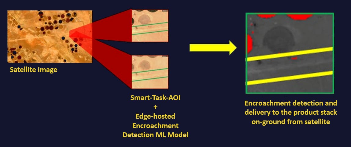
Onboard Edge computing enables delivery of something called "Smart-tasked AOI Image", which is an image of our area of interest, eliminating the minimum order area as well as unnecessary images that might not have clear visibility of the location due to cloud cover.
So, with edge computing combined with a high resolution imaging satellite, the running costs for data acquisition becomes controllable over time, the only job left to be done is automating Encroachment Detection through Machine Learning.
Once the technology and communication choices are made; the question of cost-effectiveness must be answered.
Arya is redefining the needs once again:
A satellite image for the AoI has to be acquired at the least possible cost.
The overall storage and processing costs have to be low.
Images will still have to be stored on the cloud, high-availability compute needs to require cloud compute - all have costs associated, and storage costs will only grow. Larger the data footprint per user per inspection, higher the slope of the recurring costs.
Arriving at the opt-solution
Armed with the understanding of 'edge computing', Arya determines that what his customers need is mostly the notification of encroachment, and image is needed at best for visual confirmation - not a heavy TIFF file, just a JPEG thumbnail. He could bring the encroachment detection model closer to its source: "The satellite itself"!
To harvest the benefits of satellite edge computing and provide a commercial service through the value chain, the model has to be placed on the satellite.
Imagery takes second place. When the encroachment is detected onboard by the satellite, a notification needs to be sent to the user - just some text detailing the nature of the encroachment needs to be conveyed. If the user opts for a visual confirmation, an compressed image can also be linked - maybe this can be a premium feature!
Text and a compressed images take very little storage space, ground-side processing time, thereby reducing the total cost of solution, delivering the optimal goods to meet the objectives: technology, communication, and cost-effectiveness. Now, no need to worry about customer density. It is viable to serve a much more significant customer-base irrespective of geographical spread.

Arya finds that, as a product developer, it's crucial to address the limitations of CCTV & physical monitoring services by bridging gaps rather than replacing it with a single one-size-fits-all solution. Building trust incrementally, and also factoring in the limitations of today's satellites (persistent monitoring is not yet there with high-resolution satellites, and inspecting the interiors of a building is still sci-fi).
Through ample study of customer preferences, we regard text notifications and visual imagery for inspecting encroachment as complementary enhancements to physical security personnel and mobile-connected CCTV offerings in the market. Furthermore, these features hold the potential to serve as standalone products over time.
Arya starts working on his product, with an understandably geeky and un-exciting name "EncroWatch". But hey, the product is exciting!
This is not an imaginary product. The App depicted has the potential to hit the market through the endeavors of many product developers like Arya, ably supported by innovative researchers and startups worldwide working to bring the benefits of edge-computed insights to one and all!


